Current Snowfall Total: 20.0" West Side Madison
 |
Storms blanketed Madison, Wis., with 19 inches of snow on Wednesday, and
hit the Midwest, upstate New York and parts of New England, leading to
17 deaths.
Andy Manis/Getty Images
|
Blizzard Paralyzes Much of Midwest
Around Madison, Wis., snow and wind are part of winter’s backdrop, like frosty breath and ice fishing; students rarely expect a seasonal reprieve. But the storm that whipped through the upper Midwest on Wednesday was no ordinary blizzard.For the first time in nearly 45 years, officials at the University of Wisconsin-Madison canceled all Wednesday classes — the night before — and directed all non-essential employees to stay home, affecting about 15,000 faculty and staff. By morning, roads were impassible, conditions dangerous.
“It is a rare event because people are used to dealing with snowy conditions,” said John Lucas, a university spokesman.
According to the National Weather Service in Sullivan, Wis., more than 19 inches of snow fell in Madison, the area hardest hit by a huge winter storm that blanketed the Midwest, upstate New York and parts of New England. Gov. Jim Doyle of Wisconsin closed all state government offices.
On this record day in Madison, the famous “On Wisconsin” fight song might have sounded more like “Off Wisconsin.” (Only the Milwaukee and Superior campuses of the university were open.)
Records kept by the main campus date to a storm on St. Patrick’s Day in 1965, when classes were canceled the entire day. On that day, snow piled only 6.9 inches — but on top of freezing rain.
But Wednesday was the first time that classes were canceled since 1990, when Donna Shalala, who was chancellor at the time, shut them down at 10:30 a.m. because 17 inches of snow had fallen over a 16-hour period.
“Students began lobbying the Chancellor Biddy Martin last night on Twitter and then began thanking her on Twitter, too,” Mr. Lucas said.
According to one of the university’s student newspapers, The Badger Herald, students began celebrating Tuesday night with snowball fights. Lindsay Shaw, a junior, said she was “overwhelmed with joy” at the announcement, telling the newspaper: “I’m just looking at this as a mental health day.”
Not everybody could enjoy the snow day, however. Employees at Alliant Energy were working to restore power to about 15,000 customers in northeastern and southern Wisconsin, a utility company spokesman, Scott Reigstad, said.
He was shocked — and a bit disappointed — to learn that classes had been canceled. “I went there for four years and they never shut it down,” Mr. Reigstad said.
Penny Zabel, a meteorologist with the National Weather Service in Sullivan, Wis., said blizzards are not particularly rare for the time of year, though the concentrated amount and the breadth of the storm made it so powerful.
“The size of the storm covering much of the country is much more rare,” she said, explaining that the entire system was not only bringing snow, but rain and thunderstorms extending to the Gulf Coast.
The storm dumped ice, snow and rain throughout the Midwest, from Nebraska to Illinois, but like Wisconsin, Iowa also recorded a record snowfall. In Des Moines, where 12 to 15 inches of snow fell, it was the second-largest December snow on record, the most since 1888, the state climatologist, Harry Hillaker, told the Des Moines Register.Classes were also canceled at the University of Iowa, in Iowa City, where university employees were expected to “make every reasonable effort” to report to work, and Iowa State, in Ames.
While the snow was expected to taper off later on Wednesday in the Midwest, the temperature will drop and 40- to 50-miles-per-hour winds are forecast for parts of Wisconsin and Iowa.
.JPG) | |
| 20" Before Drifting - West Side Madison, 21.12.2012 (Andre Leger) |
Blizzard turns tragic; Iowa fatalities; National Guard deployed; 18"+ near Madison, WI - MPR
Posted at 5:41 PM on December 20, 2012
by Paul Huttner
http://minnesota.publicradio.org/collections/special/columns/updraft/archive/2012/12/blizzard_turns_tragic_iowa_fat.shtml
Filed under: Winter 2012-13
Filed under: Winter 2012-13

Blizzard rages through Friday AM in parts of Iowa & Wisconsin
Fatal 25 car pileup on I-35 about 40 miles south of Mason City, Iowa
I-35 closed south of Albert Lea into Iowa
National Guard deployed in Des Moines to help scores of stranded motorists
13.8" snowfall at NWS office near Des, Moines Iowa
"Several feet high" drifts near Des Moines
100+ school districts closed Thursday across Iowa
12" snowfall total at Osseo, WI along I-94 east
18.5" snowfall totals near Madison, WI at Middleton
Near 50 mph winds gusts whipping snow around tonight
Blizzard Warnings remain in effect into Friday AM in Wisconsin & Illinois

Gradually improving road conditions Friday in the Upper Midwest.
Good travel conditions by this weekend

Image: Iowa State Patrol
Blizzard takes a toll:
The warnings were there, but the ferocity of the strongest blizzard in 2 years is taking it's toll in southern Minnesota, Iowa and Wisconsin.
As winds whipped snow into blinding squalls, a 25 vehicle pile up claimed lives south of Mason City along I-34. Numerous accidents forced the closure of I-35 south of Albert Lea.
KARE11 has details:
ROCHESTER, Minn. - Snow and wind have combined to force the closure of southbound lanes on Interstate 35 from Albert Lea to the Iowa border, according to the Minnesota Department of Transportation and the Minnesota State Patrol. The lanes were closed at 2 p.m. due to multiple accidents and per the request of the Iowa Department of Transportation. Motorists are advised not to travel until conditions improve and MnDOT and the Minnesota State Patrol open the road. No timetable for that decision has been set.The 25 vehicle pile up near Dows south of Mason City killed 2 people according to KCCI-TV Des Moines.
Heavy snowfall totals:
The storm has dumped the more than a foot of snow as advertised and then some.

"Ground Blizzard" as wind rages:
Gusts ot near and over 50 mph have created near zero visibilities in some areas.
One of the dangerous elements in blizzards is the rapid reductions in visibility that can occur. 50 mph winds get dry powdery snow airborne in a hurry. Local topography can "funnels" the snow into blinding squalls that race across freeways. One second you're driving along at 50 mph in decent visibility, the next is a total white out...you can't see 5 feet in front of you.
That's why roads get closed and unfortunately, massive pileups happen.
The La Crosse NWS pleads with drivers not to travel.


Conditions at Madison, Dane County Regional-Truax Field, WI

Conditions at Madison, Dane County Regional-Truax Field, WI
 |
| http://www.nbc15.com/weather |
Winter Storm DRACO to Hit Upper Midwest with BLIZZARD CONDITIONS
Stay TUNED to Madtown Preppers for Updates.
Stay Alert.
-MP
Blizzard Update: Iowa and Wisconsin Closed Until Further Notice
Posted by: Paul Douglas Updated: December 20, 2012 - 11:59 AM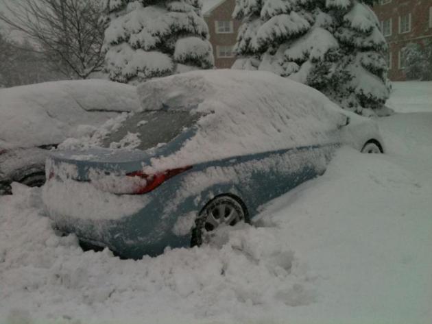
The blizzard we’ve been telling you about for a few days is pushing across Iowa into southern and central Wisconsin; winds over 40 mph dropping visibilities down to zero with treacherous to impassable travel conditions. Interstates are still shut down from near Omaha and Lincoln across much of Iowa. An estimated 30,000 people in Iowa are without power – I expect power outages to overspread Wisconsin by midday and afternoon. The heaviest snow falls over the next 8-12 hours with conditions gradually improving on Friday as snow tracks northeast and winds ease. The Twin Cities picked up 1-2” of snow but conditions there are improving. Rochester saw closer to 5-6”, but snow will taper by afternoon.
It’s the biggest snowfall for Iowa in 3 years. Cities experiencing the greatest impacts from snow, ice and blizzard conditions: Waterloo, Quad Cities, Madison, Milwaukee, Wisconsin Dells.
Chicago will continue to see numerous flight
delays and cancellations (2 hour delays right now) due to heavy rain
and T-storms – winds in the Windy City may top 60 mph by late afternoon
or evening. Lake Shore Flood Warnings are posted for Lake Michigan –
Porter, County Indiana will be hardest hit – coastal beach erosion and
flooding may rival damage from Sandy. Details below:
Blizzard Paralyzes Much of Midwest
Around Madison, Wis., snow and wind are part of winter’s backdrop, like frosty breath and ice fishing; students rarely expect a seasonal reprieve. But the storm that whipped through the upper Midwest on Wednesday was no ordinary blizzard.For the first time in nearly 45 years, officials at the University of Wisconsin-Madison canceled all Wednesday classes — the night before — and directed all non-essential employees to stay home, affecting about 15,000 faculty and staff. By morning, roads were impassible, conditions dangerous.
“It is a rare event because people are used to dealing with snowy conditions,” said John Lucas, a university spokesman.
According to the National Weather Service in Sullivan, Wis., more than 19 inches of snow fell in Madison, the area hardest hit by a huge winter storm that blanketed the Midwest, upstate New York and parts of New England. Gov. Jim Doyle of Wisconsin closed all state government offices.
On this record day in Madison, the famous “On Wisconsin” fight song might have sounded more like “Off Wisconsin.” (Only the Milwaukee and Superior campuses of the university were open.)
Records kept by the main campus date to a storm on St. Patrick’s Day in 1965, when classes were canceled the entire day. On that day, snow piled only 6.9 inches — but on top of freezing rain.
But Wednesday was the first time that classes were canceled since 1990, when Donna Shalala, who was chancellor at the time, shut them down at 10:30 a.m. because 17 inches of snow had fallen over a 16-hour period.
“Students began lobbying the Chancellor Biddy Martin last night on Twitter and then began thanking her on Twitter, too,” Mr. Lucas said.
According to one of the university’s student newspapers, The Badger Herald, students began celebrating Tuesday night with snowball fights. Lindsay Shaw, a junior, said she was “overwhelmed with joy” at the announcement, telling the newspaper: “I’m just looking at this as a mental health day.”
Not everybody could enjoy the snow day, however. Employees at Alliant Energy were working to restore power to about 15,000 customers in northeastern and southern Wisconsin, a utility company spokesman, Scott Reigstad, said.
He was shocked — and a bit disappointed — to learn that classes had been canceled. “I went there for four years and they never shut it down,” Mr. Reigstad said.
Penny Zabel, a meteorologist with the National Weather Service in Sullivan, Wis., said blizzards are not particularly rare for the time of year, though the concentrated amount and the breadth of the storm made it so powerful.
“The size of the storm covering much of the country is much more rare,” she said, explaining that the entire system was not only bringing snow, but rain and thunderstorms extending to the Gulf Coast.
The storm dumped ice, snow and rain throughout the Midwest, from Nebraska to Illinois, but like Wisconsin, Iowa also recorded a record snowfall. In Des Moines, where 12 to 15 inches of snow fell, it was the second-largest December snow on record, the most since 1888, the state climatologist, Harry Hillaker, told the Des Moines Register.Classes were also canceled at the University of Iowa, in Iowa City, where university employees were expected to “make every reasonable effort” to report to work, and Iowa State, in Ames.
While the snow was expected to taper off later on Wednesday in the Midwest, the temperature will drop and 40- to 50-miles-per-hour winds are forecast for parts of Wisconsin and Iowa.
NBC15 Weather Authority Forecast
 THE NBC15 WEATHER AUTHORITY FORECAST FROM AMY CARLSON....
***BLIZZARD WARNING UNTIL MIDNIGHT****
THIS AFTERNOON: SNOW, HEAVY AT TIMES. AN ADDITIONAL 4-7" ACCUMULATION POSSIBLE.
TEMPS IN THE LOW 30S.
TONIGHT: SNOW ENDING THIS EVENING. AREAS OF BLOWING SNOW LATE. WIND GUSTS TO 50 MPH
LOW: 20
FRIDAY: PARTLY SUNNY. BREEZY AND COLDER. EARLY BLOWING SNOW.
HIGH: 23
SATURDAY: SUNNY AND COOL.
HIGH: 25
SUNDAY: MOSTLY SUNNY.
HIGH: 26
- Monthly Snow: 4.1"
- Yearly Snow: 4.2"
- Saturday High: 46
- Saturday Low: 37
- Sunrise: 7:23
- Sunset: 4:23
- Normal High: 30
- Normal Low: 16
- Record High: 57 (1959)
- Record Low: -18 (1876)

http://madtownpreppers.blogspot.com/2012/12/winter-storm-draco-blizzard-warnings-in.html
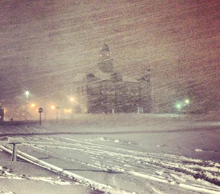
UPDATE: 20.12.2012 00:37 CST - 28 deg. SNOW,
4" Accumulation + Thunder/Lightning
(Ball Lightning Westside) - Madison
UPDATE: 19.12.2012 18:07 CST - 33 deg. Fog/Mist - Madison

Click HERE To Follow NBC15 On Facebook
Click HERE For stormmode.com Which Includes Numerous Radars And Maps
Click HERE To Submit Your Snow Pictures And Videos
_______________________________________________
MILWAUKEE (AP) -- Gov. Scott Walker is readying the troops as a strong winter storm makes its way to Wisconsin.
Walker Wednesday declared a State of Emergency as the storm advances toward the Badger State. The order mobilizes state resources, including the Wisconsin Emergency Management, the Wisconsin National Guard, the State Patrol and other agencies.
The State Patrol is recommending against travel during the storm.
Forecasters say the storm will include blizzard conditions. The heaviest snow is expected to arrive after midnight and continue throughout the day on Thursday. Wind gusts of up to 45 mph by Thursday afternoon should make travel treacherous.
The National Weather Service posted blizzard warnings for at least eight south central counties for Thursday afternoon.
Copyright 2012: Associated Press
______________________________________________
UPDATED Wednesday, December 19, 2012 --- 1:00 p.m.
DENVER (AP) -- A storm that has dumped more than a foot of snow in the Rocky Mountains could cause headaches for travelers in the Midwest.
Drivers in Iowa and Nebraska are being warned to be careful or stop driving altogether starting Wednesday evening as the first major winter storm of the season heads into the central Plains. Strong winds are expected to create blizzard conditions.
Light snow is also expected at Chicago's O'Hare International Airport on Thursday and strong winds could make visibility poor. National Weather Service forecaster Jamie Enderlen says that, combined with low clouds, could cause delays at the nation's second-busiest airport.
Delays at Denver's airport, the fifth-busiest, were averaging 30 minutes because of snow and ice Wednesday. Interstates in Colorado remained open.
Copyright 2012: Associated Press
_______________________________________________
UPDATED Wednesday, December 19, 2012 --- 12:46 p.m.
From the Governor's Office:
Madison – Today, Governor Walker issued an Executive Order declaring a State of Emergency in response to the upcoming winter storm. Heavy snowfall and strong winds are expected to be moving across the state beginning on December 19, 2012. The Executive Order will ready the Wisconsin Emergency Management, the Wisconsin National Guard, the State Patrol, and other Wisconsin state agencies.
“I issued this executive order to make sure Wisconsin is prepared for whatever this winter storm may bring,” Governor Walker said. “Mobilizing our state agency resources during this storm will ensure we leave nothing to chance when it comes to protecting the citizens of Wisconsin.”
The Wisconsin State Patrol and the National Weather Service are urging citizens to avoid traveling. Emergency Operation Centers (E.O.C.) will open tonight at 8 PM when the E.O.C. status is changed to level 3. Level 4 is the status under normal conditions. Changing the level will be the first stage of activation for Wisconsin Emergency Managment. The Department of Administration will be the point of contact regarding all state closures.
________________________________________________
UPDATED Wednesday, December 19, 2012 --- 12:15 p.m.
THIS HAZARDOUS WEATHER OUTLOOK IS FOR PORTIONS OF NORTHEAST IOWA...
AND SOUTHWEST INTO CENTRAL WISCONSIN.
.DAY ONE...THOUGH TONIGHT
A BLIZZARD WARNING GOES INTO EFFECT TONIGHT AT 6 PM AND WILL LAST
UNTIL MIDNIGHT THURSDAY NIGHT. HEAVY SNOW WILL BEGIN TO FALL TONIGHT
WITH SNOWFALL RATES OF ONE TO TWO INCHES PER HOUR TIMES. 8 TO 10
INCHES OF SNOW IS EXPECTED BY DAY BREAK THURSDAY MORNING.
.DAYS TWO THROUGH SEVEN...THURSDAY THROUGH CHRISTMAS DAY
HEAVY SNOW WILL CONTINUE TO FALL THROUGH THURSDAY WITH AN ADDITIONAL
6 TO 8 INCHES EXPECTED...BRINGING THE STORM TOTAL SNOWFALL TO 14 TO
18 INCHES WITH LOCALIZED HIGHER AMOUNTS POSSIBLE. NORTHWEST WINDS
WILL RAPIDLY INCREASE WITH WINDS OF 20 TO 30 MPH AND GUSTS TO 40 MPH
EXPECTED. THESE STRONG WINDS...COMBINED WITH THE HEAVY SNOWFALL...
WILL LEAD TO BLIZZARD CONDITIONS THURSDAY.
ONLY EMERGENCY TRAVEL SHOULD BE ATTEMPTED ON THURSDAY. STAY IN AND
BE SAFE. SPORADIC POWER OUTAGES ARE POSSIBLE AS WELL.
 |
| 6V - 12V Solar Panel Multi Purpose Battery/Phone/Device Charger S-1128 |
UPDATED Wednesday, December 19, 2012 --- 10:53 a.m.
...MAJOR WINTER STORM TONIGHT THROUGH THURSDAY NIGHT...
A STRONG LOW PRESSURE SYSTEM DEVELOPING OVER THE PANHANDLE OF
TEXAS TODAY WILL TRACK NORTHEAST INTO THE GREAT LAKES REGION AS A
MAJOR WINTER STORM ON THURSDAY. CONFIDENCE IS HIGH THAT THERE
WILL BE A PARALYZING SNOW STORM IN PORTIONS OF WISCONSIN...WITH
BLIZZARD OR NEAR-BLIZZARD CONDITIONS LIKELY.
MARQUETTE-GREEN LAKE-SAUK-COLUMBIA-IOWA-DANE-LAFAYETTE-GREEN-
INCLUDING THE CITIES OF...MONTELLO...BERLIN...BARABOO...PORTAGE...
WISCONSIN DELLS...DODGEVILLE...MADISON...DARLINGTON...MONROE
1026 AM CST WED DEC 19 2012
...WINTER STORM WARNING REMAINS IN EFFECT FROM 6 PM THIS EVENING
TO NOON CST THURSDAY...
...BLIZZARD WARNING NOW IN EFFECT FROM NOON THURSDAY TO MIDNIGHT
CST THURSDAY NIGHT...
THE BLIZZARD WARNING IS NOW IN EFFECT FROM NOON THURSDAY TO
MIDNIGHT CST THURSDAY NIGHT. A WINTER STORM WARNING REMAINS IN
EFFECT FROM 6 PM THIS EVENING TO NOON CST THURSDAY.
* TIMING...THE MORE SIGNIFICANT SNOW WILL BEGIN THIS EVENING AND
DIMINISH THURSDAY AFTERNOON AND EVENING. HEAVIEST SNOW
EXPECTED FROM MIDNIGHT TONIGHT TO ABOUT NOON THURSDAY.
* SNOW ACCUMULATIONS...12 TO 17 INCHES. THUNDERSNOW WITH RATES
OF 2 TO 3 INCHES PER HOUR MAY BRIEFLY OCCUR.
* WINDS...NORTHEAST 10 TO 20 MPH TONIGHT BECOMING NORTHWEST 20
TO 30 MPH ON THURSDAY...WITH GUSTS OF 35 TO 45 MPH.
* IMPACTS...TRAVEL BECOMING DIFFICULT TONIGHT AND CONTINUING
THROUGH THURSDAY EVENING. SIGNIFICANT BLOWING AND DRIFTING
SNOW AND POTENTIAL FOR NEAR ZERO VISIBILITY...WHITEOUTS...AND
BLIZZARD CONDITIONS THURSDAY AFTERNOON AND EVENING.
PRECAUTIONARY/PREPAREDNESS ACTIONS...
A BLIZZARD WARNING MEANS SEVERE WINTER WEATHER CONDITIONS ARE
EXPECTED OR OCCURRING. FALLING AND BLOWING SNOW WITH STRONG WINDS
AND POOR VISIBILITIES ARE LIKELY. THIS WILL LEAD TO WHITEOUT
CONDITIONS...MAKING TRAVEL EXTREMELY DANGEROUS. DO NOT TRAVEL. IF
YOU MUST TRAVEL...HAVE A WINTER SURVIVAL KIT WITH YOU. IF YOU GET
STRANDED...STAY WITH YOUR VEHICLE.
NEW VIDEO:


Winter Weather
Winter Storm Draco: Blizzard Warnings in the Midwest
Chris Dolce, Jon Erdman, Nick Wiltgen
Published: Dec 19, 2012, 5:21 PM EST
weather.com
Winter Storm Draco

Draco's Snows Move East
(MORE: Winter storm names list | Why name winter storms?)
Draco has already delivered heavy snow and strong winds to the West. Now, "phase two" of the storm is underway and will severely impact travel in the Midwest through Thursday. As we close out the week, Draco will sweep through the East Coast with rain and wind while turning on the lake-effect snow machine in the Great Lakes.
(MORE: Draco snow, wind reports)
We've got the complete details on Draco through the end of the week beginning with the Midwest blizzard next.
USA Emergency Broadcasting Network
An American Readiness Network

Today’s report is showing more information on the current Winter Storm that is hitting the Mid-West and New England States, producing heavy snow and rain.

A wise man prepares for the darkness, while a fool plays. Don’t get caught playing.
Listen to Common Sense Preparedness – An American Readiness Program on the USA Emergency Broadcasting Network at usaebn.org
In order to save as many lives as we can please pass this information around, link to our site, whatever you need to do to share this information. Together we can save lives.
USA Emergency Broadcasting Network Alerts are for informational use only. These alerts purpose is to inform you of news events in order for you to adjust your family preparedness programs. We believe that knowledge is power and in order for you to make informed decisions, we try and bring you verified information, not to increase fear but to inform you. We do not endorse any of the sources we link to in any article.
Remember: Research everything before you believe anything!!
Source Report
Significant Events:
• Sandy/Nor’easter recovery
• Winter storm-Midwest U.S.
Significant Weather:
• Cold and stormy pattern continues with heavy snow – Midwest U.S.
• Heavy snow and possible icing - Northern New England
• Critical Fire Weather: Oklahoma
• Red Flag Warnings: Texas
• Space Weather: No space weather storms observed or predicted
Tropical Activity: No tropical cyclone activity threatening U.S. territories
Earthquake Activity: No significant activity
Declaration Activity: Amendment No. 8 to FEMA-4085-DR-NY
Source: FEMA Operational Briefing
………..
Informational Links
WINTER PREPAREDNESS
HOME WINTER PREPAREDNESS
Automobile Winter Preparedness
WINTER DRIVING SAFETY
WINTER STORM SAFETY
WINTER STORM SAFETY (OUTDOORS)


No comments:
Post a Comment